Cadastral surveying and high-definition (HD) surveying serve different purposes, so the cost structure is very different. One focuses on legal boundaries, while the other focuses on high-precision digital models of land or buildings.
I’ll break down what typically drives the cost so you understand what you’re really paying for.
1. Cadastral Surveying (Legal Property Boundaries)
A cadastral survey establishes or confirms legal property boundaries.
This is the survey required for:
- land purchases
- subdivisions
- boundary disputes
- mortgage approvals
- land registration
Typical Cost Range
For residential land:
| Property Size | Typical Cost |
|---|---|
| Small residential lot | $500 – $2,500 |
| Medium property | $2,500 – $6,000 |
| Large parcels | $6,000 – $10,000+ |
(Prices vary heavily by country, terrain, and complexity.)
What You Are Paying For
1. Title and Deed Research
- checking historical survey plans
- verifying legal boundaries
2. Field Work
- locating existing boundary markers
- measuring coordinates with GPS or total station
3. Boundary Marking
- placing survey pegs or monuments
4. Survey Plan Preparation
- official signed plan for legal records
5. Regulatory Compliance
- meeting land registry requirements
Often half the work happens in the office, not the field.
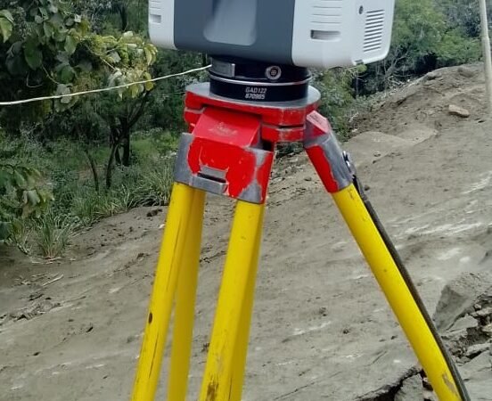
2. High-Definition (HD) Surveying / 3D Laser Scanning
HD surveying uses laser scanners or LiDAR to create extremely detailed digital models of buildings or terrain. Instead of a few measured points, it captures millions of points forming a point cloud.
This is often used for:
- engineering design
- BIM modeling
- infrastructure planning
- construction documentation
- heritage building preservation
Typical Cost Range
| Project Type | Typical Cost |
|---|---|
| Small building scan | $1,000 – $3,000 |
| Medium commercial building | $3,000 – $10,000 |
| Large infrastructure project | $10,000 – $50,000+ |
Cost Components
1. Specialized Equipment
- laser scanners ($40k–$100k equipment)
2. Field Data Capture
- scanning multiple positions around a site
3. Data Processing
- registering millions of scan points
- cleaning the point cloud
4. 3D Modeling / BIM Conversion
- converting scans into CAD or BIM models
5. Deliverables
- 3D models
- digital terrain models
- architectural drawings
Processing can take days to weeks depending on the project size.
Key Cost Differences
| Feature | Cadastral Survey | HD Laser Survey |
|---|---|---|
| Purpose | Legal boundaries | Detailed 3D data |
| Data captured | Limited survey points | Millions of points |
| Equipment | GPS / total station | LiDAR scanners |
| Typical cost | Lower | Higher |
| Deliverable | Boundary plan | 3D models / point cloud |
When Developers Use Each
Cadastral survey
- buying land
- subdivision
- legal boundary confirmation
HD surveying
- complex buildings
- renovation projects
- infrastructure design
- BIM coordination
Many projects actually use both.
💡 Practical developer insight
For most home builds or small projects, a cadastral survey + topographic survey is enough.
High-definition scanning becomes valuable when:
- the building is complex
- renovation accuracy matters
- engineering coordination is critical
Otherwise, it may be unnecessary expense.
MORE ARTICLES:
-

Approval Process Before Construction in TT
If you’re planning to build in Trinidad and Tobago, understanding the approval process before construction begins is extremely important. Many projects get delayed because owners start designing or building before completing the necessary steps. Below is the typical step-by-step process from buying land to getting permission to build. 1. Verify Ownership and Land Title Before…
-
Five Hidden Issues That Can Prevent Approval from Town and Country Planning
Many landowners in Trinidad believe that once they own a parcel of land, they can immediately start building. In reality, several hidden issues can prevent you from getting approval from the Town and Country Planning Division or other authorities. Knowing these problems early can save months of delays and significant expense. 1. No Legal Road…
-
Building Regulations in Trinidad and Tobago
Building in Trinidad and Tobago is regulated mainly through planning approvals, zoning rules, building codes, and environmental regulations. Before constructing a house or commercial building, approvals are usually required from agencies such as the Town and Country Planning Division (TCPD) and sometimes the Environmental Management Authority (EMA). Below are the most common restrictions you should…